Etchmiadzin and the Cathedral of Zvartnots

October 5, 2015

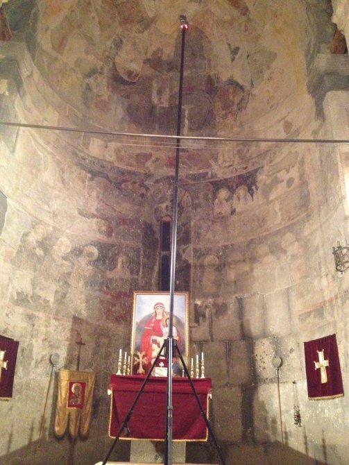
Today, our last full day in Armenia, we visited the Etchmiadzin Cathedral (Էջմիածնի Մայր Տաճար) in the city of Vagharshapat. Etchmiadzin is the first cathedral constructed in Armenia, and is considered the oldest in the world. We need to differentiate here between churches, which are structures used for Christian worship, and cathedrals, which serve as the bishop’s official site and represents the central church of a diocese.

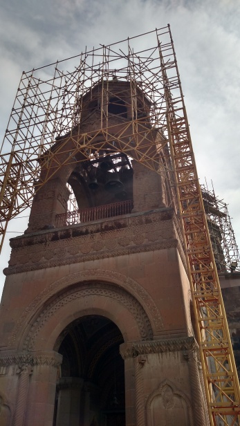
The Cathedral at Etchmiadzin is stunning for its architecture, artwork, and religious connotation. As you can see, parts of the Cathedral are enclosed in scaffolding due to a major, multi-year restoration project.

3129

3131

3133

3142

3122

3150

We met with Fr. Vahram Melikyan, Spokesman of the Catholicos of All Armenians and Director of Information Services for the Mother See. He lamented not knowing of our documentation methods a few years ago, before the restoration project began. He was very pleased, however, to hear about our success at Haghpat and stressed the importance of our continued collaboration and documentation of sites for future projects.

Father Zakaria and me at Etchmiadzin
Father Vahram Melikyan and me at Etchmiadzin

On our way back to Yerevan, we stopped at the Cathedral of Zvartnots. This site contains a number of structures that were built near the middle of the 7th century, including Zvartnots, Armenia’s main cathedral from 641 to 661 AD, and the palace of the Catholico, or head of the Armenian Apostolic Church.

Today, the Cathedral is in ruins, possibly due to an earthquake, but the remains are still impressive as the photos below demonstrate….eEIF_1587eEIF_1550

Portions of the palace complex at Zvartnots

3174

3195

3193

eEIF_1739

Jorge and I planning our next project ???

We returned to Yerevan for our final night in Armenia and, as a remembrance of our visit, we had pizza and Italian for dinner. Go figure?

The AIST team agreed that this was one of the most productive and enjoyable projects we have worked on over the past ten years, and we are looking forward to our next one here.

Bart McLeod, Jeff Du Vernay, Jorge Gonzalez, and Garrett Speed are some of the finest 3D Heritage field experts anywhere, and to have them all working on the Haghpat Monastery Complex Project is a tremendous advantage for AIST. Steven Fernandez will be a major contributor to the project when he begins to work with the data we collected back at the AIST computer and GIS labs. Lori Collins, AIST Co-Director, has been invaluable at every step of the project, and will play a key role in preparing the processed data for the website, which will hopefully be up and running in December or January.

Again, we cannot say enough about the the people of Haghpat and Armenia that we encountered who made us feel welcome, and we thank them for their support and hospitality.

Finally, I hope you all have enjoyed reading about our adventures as much as we enjoyed Armenia and the project.

Thanks.

Travis

The Pagan Temple at Garni and the Geghard Monastery

October 4, 2015

Today we visited the Classical Hellenistic Temple at Garni, thought to have been constructed in the 1st century AD, and dedicated to the sun god Mihr. It is the only Greco-Roman building with collonnades in Armenia. The temple remains as one of a few symbols of pre-Christian Armenia.

The temple was destroyed in a 1679 earthquake whose epicenter was believed to have been located in the gorge that surrounds Garni. Although the structure was devastated by the quake, most of the original construction stones were scattered around the site. From 1969 to 1975, the temple underwent reconstruction.

Garni and me
Garni and me
2987
The Garni Gorge. Its beauty and immensity cannot be captured in a photograph.
2988
The reconstructed Temple of Garni, front
2994
The reconstructed Temple of Garni, side

We also had the opportunity to visit the Monastery Complex at Geghard, a short distance from Garni. We were told that Geghard had a mystical quality, a point with which we could not argue. It is beautiful, as the following photos will show…

3014

3018

3019

3020

3029

3032

3041

3054

3058

3088

3092

3067

We returned to Yerevan for a great dinner and relaxation.

Finishing our Work at Haghpat

October 1. 2015

Over the past couple of weeks our team of AIST specialists has worked diligently to acquire spatial and historical research data at the Haghpat Monastery Complex. Excellent weather and exceptional cooperation from the current monastery priest, Father Ghazear Torosyan, and past rector, the Very Reverend Father Asbed Balian, now serving as the Armenian Patriarchate of Jerusalem, facilitated our work.

Father Ghazear and Me in front of the Bell Tower
Father Ghazear and me in front of the Bell Tower

We were able to collect more data from more related portions of the site then we had originally expected. including the Kusanats Anapat (St. Tiramair), a chapel about half a kilometer from the Monastery. The small church was built in the 13th century, and is located at the top of the hill that holds the village cemetery. We scanned and photographed the church and three exceptionally large khachkars (stone crosses) on its south side that date to the late medieval period.

Work at the Kusanats Anapat (St. Tiramair) Church

We also were able to complete the interior of the Bell Tower, and importantly the entire interior and exterior defensive walls of the Monastery.

Portion of the exterior wall containing a carved crossed stone monument
Portion of the exterior wall at Haghpat containing  carved crossed stone monuments

We left Haghpat on Thursday, October 1. Many of the villagers that we had become friends with expressed their thanks for our work and asked that we return soon. We made our way to Lake Sevan, an Alpine-type lake lying some 6,000 feet above sea-level. We were about the only visitors to the resort community due to our arrival during the off-season. It was cold and blustery.

Father Gahzar, Vacho and Raiza Ghadyan (Monastery caretakers, and the AIST team
Father Gahzear (center); Raiza and Vacho Ghadyan, Monastery caretakers (right); and the AIST team in front of the Gavit at Haghpat

Our return to Yerevan was an adventure because of events, which included a half-marathon race, in the center of the city. At our every attempt to reach our hotel, the traffic was diverted. We ended up in a traffic jam, the likes of which none of us had ever witnessed. We were halted in the middle of the intersection for about a half an hour, and each vehicle wanted to go in a different direction. We were finally able to make our escape to the left in the photo below, ultimately reaching our hotel.

Yerevan traffic jam
Yerevan traffic jam

In Yerevan, we had the opportunity to visit the craft market, and it was great to be able to see the current artistry of the Armenian craftspeople.

Yerevan Market
Yerevan Market

2879

2780

We also had the opportunity witness Armenian interactions

2947

2954

We also had the pleasure of visiting with Varazdat Hambardzumyan and his son at his workshop in Yerevan. Varazdat is an artist who creates khachkars, or Armenian cross-stones] (խաչքար). His work has been commissioned around the world.These sculptures are usually carved from stone and represent focal points for religious worship or memorials that facilitate the communication between the secular and divine. In 2010, Armenian Cross-Stone Art was inscribed on the UNESCO list of the Intangible Cultural Heritage of Humanity.

Varazdat Hambardzumyan, (left), his on (center), me, and his apprentices in the rear.
Varazdat Hambardzumyan, (left), his son (center), me, and his apprentices in the rear
2899
An example of Varazdat’s work in progress
2901
Production of a khachkar in Varazdat’s workshop
Crossed stone monument in the Haghpat cemetery
2961
An ancient khachkar
3111
Examples of khachkars in Etchmiadzin

Yerevan is a vibrant city in the midst of a construction boom. The people are great and the food is fantastic.

Elevated Laser Scanning Enables Monastery Dome and Frescos to be Recorded in High Detail

Another wonderful day of work with beautiful weather at Haghpat Monastery. We have worked two nights and part of the morning and then have been sleeping in the day for last two days. We did the night scanning to minimize disturbance to tourists and activities at the Church site. Scanning and imaging in the St. Nishan Church with its dome and painted frescos and magnificent architecture, was both challenging and exciting. Using a military-grade mast system that we brought to Armenia, we were able to elevate our equipment -both the scanner and the photographic equipment- and remotely control them using tablet and smartphone interfaces. In this way, we were able to stay in close proximity to the surface areas we were documenting, and the data obtained is much higher resolution, more accurate and representative than if we were performing ground based documentation. This area was imperative to document with highest detail for preservation and conservation strategies as well as being able to present these data to the public.

11220764_10204980646701690_5301295261492243840_o

Our scanner on the mast system is collecting data from the top of the dome area in a parallel position

We also were able to continue our GPS survey work today. Bart was amazed at the number of satellites that are available in this part of the world. He has access to the North American, Russian and European satellites here, and it is making for great precision and productivity in collecting data. We now have GPS positions on all of the cultural features, architectural elements, and important attribute and conditional areas. GPS photography is also being acquired, noting areas of management and preservation concern and areas of interest for visitors and researchers. GPS is also being utilized to add control for geolocation in our survey, especially for the scanning and photogrammetry surveys.

2015092795110158

Image showing distribution of satellites that are available

IMG_20150929_152614346GPS survey of architectural elements at Haghpat        

My routine of work at the site includes the sharing of my morning breakfast with a new friend. A village cat has taken a liking to me (or my breakfast) and follows me around during my survey work outside. She is really affectionate and has been fun having her following me around. 

IMG_20150929_124213233

Haghpat cat friend

When we return to the hotel, the routine continues with data backup and processing to make sure we have recorded all the details we need. Photos are reviewed, scan data is registered and reviewed and all is stored in multiple locations to be sure all is archived.

HAMAZ_03_LORI

Initial results from laser scanning are highly detailed and allow critical understanding of the architectural features at Haghpat

Springhouse

The laser scanning data (the Monastery Water Spring is shown here) is accurate to <2mm and provides a detailed documentation of the entirety of the site.

The town people and Church representatives here have been wonderful and so supportive of our work. We plan to finish work this week and take time to scout and perform reconnaissance for future phase work on this important project. More from Armenia tomorrow!

IMG_20150929_125051877_HDR

Scanning the exterior wall feature at Haghpat. The area of fired bricks and basalt stone that is shown here is in the oldest section of the wall. High artisan workmanship is noted in both the enclosing wall and in the watchtower areas.

Prepping for Night Scanning

Monday, September 28, 2015

Today we are reversing our sleeping schedules to accommodate night-time scanning for the next two days at the Haghpat Monastery. We will be conducting our work in two of the more heavily visited areas of the monastery, in order to reduce any interference with tourist traffic and daily activities. Tonight we work in two important areas: the Gavit and the Cathedral of St. Nishan.

IMG_20150927_183956000_HDR

Sunset from the Hotel showing the Debed Gorge area

The Cathedral is remarkable for its fresco-painted dome, triangular niches, intersecting vaults and cruciform shape (not so obvious from the exterior). While we are now concentrating on the interior, the exterior of this structure is also interesting, with a large bas-relief monumental sculpture carved into its pediment. In the Cathedral, we will perform high resolution scanning at ground and elevated positions, as well as gigapixel and other imaging techniques. Cross-stones and special features and details will be scanned using close range methods as well as our phase shift scanners.

The Gavit served as a narthex-or entrance into the church-and at Haghpat, it is an area of vaulted wings that form a hall. The vaults in this portion of the site were constructed at varying times, but are a great example of medieval architecture. Our laser scanning of these structures will be able to forensically examine architectural aspects of construction and allow for views that are not otherwise possible. The interior scanning will be brought together with the exterior documentation, providing a complete 3D documentation of the entire site and terrain features.

SALA02_03_BLOG

Laser scan detail showing interior vault features at Haghpat

A Bit More on the Background of Haghpat and the Rationale for the Digitization Effort

The history of Armenia and the traditions and identity of its people were and are profoundly influenced by Christianity. Among the most important symbols of the country’s patrimony are the churches and monasteries that played a crucial role in the development of Armenia’s cultural and ancestral legacy. These monastic complexes were centers for advancements in the arts, sciences, and architecture that impacted the development of these disciplines throughout Medieval Europe and Western Asia. Today, these structures, their contents, history, and surrounding landscapes serve as direct ties to Armenia’s exceptional past. They are tangible links that evoke a collective memory and maintain a sense of the Armenian community and identity. They also represent cultural resources that are at significant risk, threatened by natural and human actions.

DCIM101MEDIA

Image taken from the AIST UAV platform

Known originally as Sourb Nshan (Saint Nishan) of Haghpat, this monastery was selected as the inaugural project for the Armenian Heritage and Social Memory Program because of its major historical significance, its recognition as a World Heritage Site, and the completeness and range of its ancient structures and features. The architectural complex is largely intact and retains its original character. Beyond the superb architecture, the compound includes frescos, bas-reliefs, and monumental sculptures that will serve as an ideal presentation of Armenian culture to the world.

The Haghpat Monastic Complex, in the northern Lori district, was the first location in Armenia to be selected as a UNESCO World Heritage Site (http://whc.unesco.org/en/list/777). It was inscribed on this exclusive list because “it is of outstanding universal value” that represents “the highest flowering of Armenian religious architecture, whose unique style developed from a blending of elements of Byzantine ecclesiastical architecture and the traditional vernacular architecture of the Caucasian region” in the 10th to 13th centuries. The complex at Haghpat is also recognized by the International Council on Monuments (ICOMOS) as one of most culturally significant in Armenia.

GPS Survey and 3D Laser Scanning Intensify at Haghpat Monastery

Sunday, September 27, 2015

Today we moved into high gear so that we can document not only the entirety of the Haghpat Complex, but can also digitally record and preserve some of the important surrounding architectural features that directly relate to the Complex. Other monuments of the Haghpat village that are important, but located outside the monastery walls include: the Old Church ruins (first church built in Haghpat), about 1.5 km outside the wall; and the monastery water spring building that provides the source of water for the village as well as for livestock.

IMG_20150927_143540695_HDR IMG_20150927_144735818

The Monastery Water Spring has water basins for people inside and cattle watering areas outside. Water is also piped throughout the village from here.

IMG_20150927_103123082

Recording an inscription lintel area at the Old Church (Jegrashen Church Site)

GPS survey has been an important aspect of our work, with exact positioning documentation providing reference control for our survey, as well as providing data that will be used to produce cartographic mapping products. Additionally, GPS is useful for condition and asset survey and will provide a permanent record of located features and their condition. We are recording with GPS photography in addition to the geolocation information.

e_DSC0334

GPS survey of features include architectural and monuments as well as plantings that relate to the landscape of the monastery.

Each night the team works at processing data collected from that day, including basic registration and making sure that we have covered all areas with our survey. Data back-up and management is also an important part of the nightly routine, with all data secured in three distinct back-up locations to insure that all is archived and protected. Processing involves quality control and assurance checking to verify the correct resolutions and coverage were obtained. Viewing and analyzing the data in 3D allows us to plan for any data gaps or areas that we will return to in the continuance of the work. Shown below is an example of the raw data collected from the Haghpat belfry or bell tower area, which we are continuing to work at in our landscape and exterior survey. Our finalized point cloud data will be colorized and highly representative and accurate assessment of the built environment and terrain (accuracy to less than 2 millimeters). Because the data is 3D, we can slice in the software to view interior structures, readily understanding building floor plans and shapes that are not easily discerned otherwise. These data will allow detailed and accurate Computer Assisted Drawings (CAD) to be produced, documenting the architectural as built design, conditions, and styles of this World Heritage site.

bell-tower

Raw initial registration of point cloud data from our terrestrial laser scanning survey work in the belfry area of the site.

Grigor Inside 2

Grigor Inside 5

Slicing the 3D data to reveal the building’s floor plan 

Today, being Sunday at the site, there were several visitors, worship and ceremonies taking place, including a christening of several babies from the village that we were invited to witness.IMG_20150927_150805084

Christening event at Haghpat Monastery today

Tomorrow night (Monday) we will be pulling an all-nighter in the two most important rooms at Haghpat, the Gavit and the Cathedral of St. Nishan, with its dome and painted frescos. The monastery closes to the public at 6:00pm, but we received permission from the Arch-Bishop in Yerevan to conduct our work at night in order to avoid interfering with visitors during the the 3D laser scanning and photogrammetric work.

Saturday is a Rest and Reconnaissance Day

Update and a Bit of Project Background

Digital Documentation of the Monastery Complex is in full swing. A variety of 3D scanners, photography and photogrammetry, Aerial drone images, Global Positioning System and GPS camera work, video and audio recording are all continuing at the site.

The visual images are really great, and will provide us the data needed to address numerous applications that range from restoration, preservation, heritage tourism, education, and more. The Armenian people, native and diaspora, are enthusiastic about what we are doing, and more importantly-why we are doing this project. 

The Armenia Heritage and Social Memory Program is designed to be composed of a series of individual segments or phases that will digitally document important heritage sites in Armenia. Focus is concentrated on specific complexes, sites, or features of Armenian history and heritage, resulting in a comprehensive study and presentation of Armenian history. The initial project, The Haghpat Monastery Complex has been selected because it offers an exceptional microcosm of the types of Armenian history, identity, and social memory that are at the core of the program. The foundational aspects of Armenian heritage – language, religion, literature, art, and architecture – are well represented at Haghpat. Further, the monastery complex remains a central cultural and historic feature within the contemporary village. 

Screen Shot 2015-09-26 at 6.44.38 PM

Map of Armenia with location of Haghpat illustrated in northernmost Lori Province (Image after 2013 en.wikipedia.org).

Saturday, September 26, 2015

Today was a day to rest  from a week of hard survey work at Haghpat and tour the countryside a bit, doing reconnaissance of additional locales and experiencing Armenia. After a drive, we were off to see the nearby Sanahin Monastery and the Odzun Church sites. The name Sanahin translates to “this one is older than that one” and there is a bit of a rivalry between Sanahin and the nearby Haghpat sites that can be viewed from one another across a plateau area. The image below shows the view looking east toward Haghpat.

IMG_20150925_151153748_HDR

The Sanahin Monastery has a number of elaborate Khatchkars or cross-stones, as well as significant architectural features. A large restoration project is underway at the site and we are hopeful that our documentation will be useful for management and restoration efforts that are ongoing in this region.

The monastery is undergoing some major renovations. The main area of concentrated treatment is on the dome.

IMG_20150926_111326403_HDR IMG_20150926_111942948

We walked the entire grounds and took photos back across the plateau. At Odzun, which is an Armenian basilica that was built between the 5th-7th century, was unique, with a large funerary monument central to the site.

IMG_20150926_133527688_HDR

At the church locale I couldn’t resist taking a selfie, along with documenting the beautiful surroundings.

IMG_20150926_134232981_HDR

IMG_20150926_135514114

Several of the elaborately carved cross-stones are in good condition at this site.

IMG_20150926_113015801_HDR

After hiking around the site, we were all ready to eat and stopped for lunch and to sample the BBQ and beer at the Alaverdi Tavern next to the Debed River that serves as a geographical separation between Haghpat and Sanahin. ‪The restaurant is located off the Yerevan-Tbilisi highway, 4 km North from Alaverdi City, in the Lori Province.

IMG_20150926_143306828 IMG_20150926_151952210

The crew has loved the food in Armenia. Many of the restaurants are farm to table kind of concepts, with delicious meats and lots of vegetables. Jeff, who is a vegetarian, has found lots to eat (and drink) with all the potatoes and vegetables (and of course beer). The group has become fond of the local beer called Kilikia, from the Yerevan Brewery Factory.

IMG_20150926_144649329_HDR IMG_20150926_144640702

I love the meat and potato choices, and have found some friends to share in the food…(Lori would be happy). Two street/cafe dogs were glad to help with my lunch! Tomorrow we will be back at Haghpat continuing our work to digitally preserve significant Armenian heritage.

IMG_20150926_143502451_HDR IMG_20150926_154515693

Digital Documentation Survey Continuing at Haghpat

AIST crew continues to do amazing digital documentation at the Haghpat Monastery World Heritage Site, including getting our equipment elevated to capture interior domes and architectural intricacies. Outside, use of drones, GPS and terrestrial LiDAR that documents out to 330 meters is being used along with close range detail scanning and photographic techniques.

Using a mast system we are able to elevate the scanners to obtain better line of sight for architectural documentation. The mast systems are20150925_130538 also being utilized for photographic and videography set ups, allowing high resolution techniques to be applied to inaccessible areas of the site. Close range scan details are taken that will be merged with point cloud data from the structure. In this way, we are documenting even the finest of details and architectural features, some of which are damaged from time, weathering and events that have deteriorated their surfaces and diminished their details. The AIST team from the University of South Florida is also well equipped to document this large World Heritage complex at a variety of scales. We will use survey grade GPS to provide control for the project and to create a database of features and resource locations that will help in the management and preservation of this universally-valued treasure. Unmanned aerial vehicle platforms are allowing for newer techniques in landscape documentation such as Structure from Motion, where we will use software and mapping techniques to make 3D terrain models from 2D data such as videos. Photogrammetry techniques will also allow 3D modeling of the site terrain and structural elements. IMG_20150924_093236100P1050339We are documenting not only the entirety of the interior of the complex structures, but all of the site exterior features and environmental terrain settings. In this way, we will have digitally preserved and will archive this important site for future generations and for needed management and planning for long term preservation.

P1050220estela01

Lasers, drones, GPS, photographic techniques are helping to digitally preserve a World Heritage treasure in Armenia

Thursday, September 24, 2015 – Haghpat, Lori Province, Armenia

This was oIMG_20150920_181252182-2ur third day at the Haghpat Monastery Complex, and we could not ask for better project conditions. The weather is great (80 degrees and no humidity), brilliant sun, and clear skies [Hope I did not just jinx us]. The people at the Gayane Hotel have gone out of their way to accommodate us. Food and drink are great, and the location perfect for our work, only a five-minute drive to the site. Perhaps we will have a video of the drive soon.

The AIST field team is the best! Bart McLeod, Jorge Gonzalez, Jeff Du Vernay, and Garrett Speed may be the best 3D heritage documentation team in the U.S. Their experience, work ethic, ability to solve problems, and overcome just about any obstacle are really remarkable. Each has their specialty, but they are also multi-talented, and IMG_3589
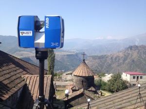
work together as a well-oiled machine. We could not ask for a better field crew.To support my assertions, I ave seen the data collected so far, and it is incredible, especially considering the conditions we have to work under. After a couple days we have figured out the daily patterns of visitors and weather. Jeff manually secured the scanner on the roof of one of the structures for a series of scans in the gusting afternoon winds. Bart, Jorge, and Garrett learned to work around the frequent groups of tourists. We have even managed to get the Priest involved and have 3D scanned him for the archive as well!


 20150924_021849_Richtone(HDR)[2]

Garrett successfully flew the UAV for the second time today. The data capture is amazing, reaching areas of sculpted stone more than six stories high. It will be a major part of the project’s products, along with his high-resolution and gigapixel photography and photogrammetry.

WP_20150924_001

DCIM101MEDIA

Jorge has been concentrating on capturing sculptures with our handheld scanners and his unique photographic talents to capture the various textures of the architectural fabric.

estela01_REAL    estela01

Bart has been conducting scans of the interiors of the monastery’s structures, and Jeff has been doing the exteriors. They have left little uncovered, the combined data is providing views that have never been seen, even by the original builders. Great work!
Grigor Inside 4 Grigor Inside 3 Grigor Inside 1southside of church
More soon…

Travis F. Doering, Ph.D.

National History Museum of Armenia

We spent a beautiful Sunday morning at the National History Museum in Yerevan, Armenia’s capital city.

P1050088 P1050087

Unfortunately, photography was not permitted inside, so we cannot show the incredible artifacts on display. Objects dated from 300,000 years ago to the 1950s. Bronze Age items were tremendous. The collections are second to none.

Fortunately, there was an exhibition of Crossed Stone monuments that we could photograph in the entrance hall.
P1050093P1050108

Tomorrow we make our way to Haghpat to begin the documentation project. As we progress, we will heed the following quote…

P1050116